


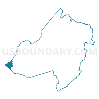
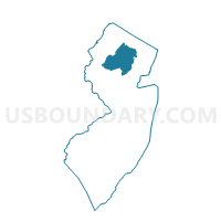
Washington township voting district 12, Morris County, New Jersey
About
Outline

Summary
| Unique Area Identifier | 621168 |
| Name | Washington township voting district 12 |
| County | Morris County |
| State | New Jersey |
| Area (square miles) | 4.32 |
| Land Area (square miles) | 4.24 |
| Water Area (square miles) | 0.08 |
| % of Land Area | 98.14 |
| % of Water Area | 1.86 |
| Latitude of the Internal Point | 40.79313820 |
| Longtitude of the Internal Point | -74.85903500 |
Maps

Graphs
Select a template below for downloading or customizing gragh for Washington township voting district 12, Morris County, New Jersey


Neighbors
Neighoring Voting District (by Name) Neighboring Voting District on the Map
- Lebanon township voting district 1, Hunterdon County, NJ
- Lebanon township voting district 2, Hunterdon County, NJ
- Lebanon township voting district 6, Hunterdon County, NJ
- Mansfield township voting district 3, Warren County, NJ
- Mansfield township voting district 4, Warren County, NJ
- Mansfield township voting district 5, Warren County, NJ
- Washington township voting district 5, Morris County, NJ
- Washington township voting district 6, Morris County, NJ
Top 10 Neighboring County Subdivision (by Population) Neighboring County Subdivision on the Map
- Washington township, Morris County, NJ (18,533)
- Mansfield township, Warren County, NJ (7,725)
- Lebanon township, Hunterdon County, NJ (6,588)
Top 10 Neighboring Place (by Population) Neighboring Place on the Map
Top 10 Neighboring Elementary School District (by Population) Neighboring Elementary School District on the Map
- Washington Township School District, NJ (18,533)
- Mansfield Township School District, NJ (7,725)
- Lebanon Township School District, NJ (6,588)
Top 10 Neighboring Secondary School District (by Population) Neighboring Secondary School District on the Map
- North Hunterdon-Voorhees Regional School District, NJ (51,047)
- West Morris Regional School District, NJ (38,870)
- Warren Hills Regional School District, NJ (24,013)
Top 10 Neighboring State Legislative District Lower Chamber (by Population) Neighboring State Legislative District Lower Chamber on the Map
Top 10 Neighboring State Legislative District Upper Chamber (by Population) Neighboring State Legislative District Upper Chamber on the Map
Top 10 Neighboring 111th Congressional District (by Population) Neighboring 111th Congressional District on the Map
- Congressional District 11, NJ (674,349)
- Congressional District 7, NJ (672,885)
- Congressional District 5, NJ (666,551)
Top 10 Neighboring Census Tract (by Population) Neighboring Census Tract on the Map
- Census Tract 315, Warren County, NJ (7,725)
- Census Tract 102, Hunterdon County, NJ (7,664)
- Census Tract 462.97, Morris County, NJ (3,649)